3. Spatializing Values in Heritage Conservation: The Potential of Cultural Mapping
- Erica Avrami
Inventories have long been a foundational tool in the identification and management of heritage. Mapping historically served as a visual device to locate, navigate, document, and delimit heritage places and their physical contexts. The burgeoning field of cultural mapping expands the scope of this enterprise by seeking to understand the social relationships and cultural traditions associated with such places. Drawing upon the social sciences and the humanities, as well as new geospatial information technologies, cultural mapping is a means of exploring people-place dynamics for multiple aims. It can generate new forms of knowledge about both tangible and intangible heritage within a community and provide new platforms for analysis and decision making. It can likewise serve as a vehicle for engaging populations in a dialogue about what they value within their community, and empower them to effectively create and re-create heritage.
As values-based approaches to heritage conservation evolve, how all stakeholders—not just heritage experts—ascribe meaning to places plays a more central role. Participatory practices of data collection recognize more people and more values in the heritage enterprise. Cultural mapping exercises can produce data about not only built heritage, but also traditional crafts, performances, vistas, spiritual locales and practices, long-standing businesses, places of congregation, important travel and access routes, community anchors, stories, personal associations, et cetera, many of which may not be tied to places considered historic but still form critical connections in social-spatial dynamics. These rich and diverse catalogues can raise awareness about intangible and tangible heritage and the links among them, and potentially underpin community identity and resilience through shared memories and narratives.
These practices fundamentally seek broad inclusion in terms of both participation and the assets identified. However, heritage practitioners have a primary charge of preserving values through the built environment, which involves prioritized, and to some degree exclusionary, decision making. Physical conservation does not ipso facto preserve all values. How can practices of cultural mapping more directly inform our understanding of how a broader range of values are associated with place and space—of how values are spatialized within the built environment through spatial-social dynamics? And how can a more robust understanding of how values are spatialized in turn inform more responsive and innovative heritage decision making?
This paper examines these questions through a brief historical overview of the evolution of heritage inventories and cultural mapping; a review of the literature on cultural mapping, its applications, and its implications; as well as an illustrative case, New Gourna village in Egypt, which addresses how cultural mapping can spatialize values and inform decision making.
Early Inventories
The act of mapping as a tool for communicating about space and spatial relationships traces back thousands of years; places of significance are indicated on maps throughout the history of cartography. The modern notion of mapping heritage places is integrally linked to the identification of said places through surveys or inventories that seek to collect information as well as communicate value ().1 The inventorying of cultural resources in the Western world dates back to at least the Valor Ecclesiasticus when, in 1535, Henry VIII called for a survey of church properties as part of the dissolution of the monasteries. Some of the earliest Italian inventories date to the eighteenth century, as does the first in France, where a commission des monuments undertook a nationwide survey during in 1790s to catalogue cultural resources seized from the church and nobility during the revolution (, 11). The Commission des Monument Historiques was later established in France, and published its first catalogue of nearly one thousand sites in 1840.
Drawings and then lithographs were widely used to visualize surveyed heritage places, beyond locational mapping. The advent of photography greatly changed the medium, content, and meaning of these inventories when, in 1851, the Mission Héliographique deployed five photographers to document the historic monuments catalogued by the aforementioned Commission. Under the direction of Eugène-Emmanuel Viollet-le-Duc, the survey sought to collect information for possible restoration projects. One can regard this Mission as a very early, though serendipitous, instance of cultural mapping that fundamentally sought to understand people-place relationships: “Unlike lithographs and drawings, the photographs of the Mission depicted monuments neither as ghosts of the bygone nor as blank slates, but rather as evolving structures functioning as meaningful signs within cultural memory in their current state and environment” (, 308). Comparing this early photographic documentation to traditional recording methods lays bare the profound differences created by visual representation. While still an interpretive medium, photography was less forgiving, and in this instance not as easily manipulated in service of Napoleon III’s efforts “to construct French cultural memory around ancient monuments as signs of historical continuity and unified national identity” (, 297). These monuments were very clearly an operative element of the present, part of people’s everyday lives. The Mission team submitted more than 250 photographs to the government, which after reviewing the results refused to allow their publication ().
By the early 1900s, as the Industrial Revolution brought change at a pace previously unimaginable, heritage lists and inventories were increasingly prevalent in the European context, and were viewed as a fundamental policy tool to further heritage conservation agendas (). The Athens Charter of 1931 explicitly called for “each country, or the institutions created or recognised competent for this purpose, [to] publish an inventory of ancient monuments, with photographs and explanatory notes” (, sect. VII.c.1).
A curatorial perspective on the built environment underpinned inventory efforts during much of the twentieth century, driven by an essential view of cultural heritage as assets to be stewarded for future generations because of their inherent value as physical markers of history.2 Heritage experts—first architects and historians, then conservation professionals as the field evolved—drove and managed these inventories, largely under the auspices of government agencies, collecting graphic and written documentation in the archival tradition.
Cultural Mapping Emerges
In the post–World War II era, several factors converged to radically shape contemporary theory and practice related to cultural mapping and its application to heritage management, including:
computing technology and increased access to it;
a newfound attention to spatiality in critical social theory;
the emergence of critical cartography and its recognition of the role of political power in geographic knowledge;
postcolonialism and the rise of Indigenous agency in both managing heritage and mapping territorial space;
political movements of the 1960s, which challenged authority and championed social justice;
and new forms of participation in governance and activism in the face of top-down planning, which influenced heritage policy and practice through a societal-values-based discourse.3
The advent of flight greatly influenced the realm of cartography, particularly after World War I. Suborbital and satellite imagery further revolutionized photographic documentation of the Earth’s surface, and thus its mapping. By the 1960s these new forms of visualization and advances in computing gave rise to the field of geospatial technology or geomatics, which includes geographic information systems (GIS). Initially, barriers to entry—that is, high cost and required technical skills—precluded the use of GIS beyond governments and wealthy private entities (; ). The birth of the internet, along with higher-performing computer hardware and improved software accessibility (especially in recent years through open-source platforms), opened doors to new mapmakers and users, in turn broadening mapping applications well beyond cartography. At the same time, this technological advancement transformed the map as object from something static and two-dimensional to a networking system, connecting multimodal forms of data in dynamic ways.
In addition to these technical advances, scholarship and activism born of the 1960s political revolution raised new questions about the creation and control of space within society. Critical social theorists, especially Henri Lefebvre (), Edward W. Soja (), and David Harvey (; ), forged a discourse arguing that space is socially constructed and made productive through social practices. As Derek Gregory notes, “The analysis of spatial structure is not derivative and secondary to the analysis of social structure[;] … each requires the other” (, 120). Neil Smith (; ) and Dolores Hayden (), in their explorations of urban power and place, extended these lines of inquiry to heritage conservation. This raised new awareness about “the created spatiality of social life … as both an outcome and a medium for the making of history” (, 57–58). People and places are integrally linked. The heritage enterprise could no longer isolate issues of value and meaning to fabric and historical associations, and mapping places meant understanding these complex social-spatial relationships in new ways.
In mapping, however, lies inherent power. Maps are never neutral, never simply documentary or revelatory; mapping is a political and creative process (). Critical cartography seeks to expose and challenge this privilege by exploring how mapping can be part of an emancipatory practice (). As Alys Longley and Nancy Duxbury observe, “Mapping can be a colonizing, territorial practice—or a way of undoing languages of territory and privatization” (, 10). As an example, Indigenous communities in North America have employed geospatial technologies to protect tribal resources, territories, and practices since the 1970s, as a means of preserving cultural knowledge and sovereignty (). Epitomizing Michael Stone’s classic categorization of “map or be mapped” (), Indigenous communities were early practitioners of cultural mapping as an insurgent act in the postcolonial era, as they sought to defend lands against encroachment and recover lost territory (). Cultural mapping is also advocated and implemented through policy as both a means of heritage inventory and a form of restorative justice, “to stabilize and revitalize the cultural identities of displaced, fragmented, and stigmatized indigenous communities” (, n.p.).
Cultural mapping as a means of empowerment extends beyond Indigenous communities. Asset-based community development (ABCD) emerged in the 1990s, for example, empowering local communities through participatory inventories of their resources and capacities, often centering on the historic places and cultural assets they value. A primary aim is to foster civil society and collective agency toward collaborative economic development (). Such asset mapping has emerged as an important tool in urban planning to integrate the arts and cultural activities into sustainable community development ().4 Heritage is a cornerstone of such mapping, including both tangible and intangible assets. But an important point of evolution is the instrumental role of heritage in many contemporary cultural mapping initiatives.5 Such cultural mapping does not simply create an inventory or collect data about and manage heritage. Rather, it is designed in service to broader societal aims, such as economic development, social cohesion, and participatory governance, or in some cases to challenge existing governance structures and actions through “counter-mapping.” By focusing on these more instrumental aims, cultural mapping looks beyond heritage assets to understand place attachments in relation to broader social and spatial dynamics. In doing so, heritage, tangible and intangible, is not simply the object of cultural mapping but rather a vehicle through which societal values are made manifest.
Mapping as Essential and Instrumental
As noted above, traditional inventories emerged from essential views of heritage and its value—the “cultural heritage as a legitimate end in itself” argument (, 21). Ontological and technical progress has advanced these catalogues as multimodal and relational databases that geospatialize heritage places and practices. But deployment is fundamentally driven by the goals of recording and managing heritage places. Cultural mapping has the potential to serve as a tool in service of these inventories and their heritage-values-based goals. Especially through participatory processes, cultural mapping can identify, even create, new heritage. As Longley and Duxbury note, “The process of mapping often reveals many unexpected resources and builds new cross-community and cross-sector connections” (, 1).
Cultural mapping provides a medium through which different stakeholders and disciplines can bring to bear their respective expertise and knowledge about heritage, from spatial ethnography to economic and demographic analysis. In so doing, it extends beyond the function of a documentary inventory to a means of correlating different types of data and analyses, such that we understand heritage not simply as a resource, but as a set of relationships demonstrating the “lived experience of space and place” (, 2).
Collaborative mapping that includes robust community participation can forge a network that connects multidimensional data (text, sound, still and moving images, and so forth) about people, places, and practices, providing what Kai Khiun Liew and Natalie Pang refer to as “different ways of locating their collective belongings and memories” (, 336). Such processes of elicitation can establish “creative platforms that connect people more deeply to each others’ histories embedded in the geographies of place in order to help disturb histories of forgetting” (, 2).
While cultural mapping may serve these essential heritage aims, the literature is rife with research, case studies, and guides promoting the instrumental role of cultural mapping in achieving broader societal aims, from promoting cultural understanding and cohesion (; ; ) to supporting community, economic, and regional development (; ; ; ). More discrete aims include enhancing tourism potential and marketing (; ), informing culture-driven urban planning and policy, and preparing citizenries for more robust engagement in civil society in general ().
Cultural mapping is likewise employed as a tool for social justice and political activism, especially in the face of change and oppression, as evidenced through its aforementioned use by Indigenous communities. UNESCO especially champions this empowering role of cultural mapping, noting important distinctions between the aims of more traditional heritage inventories and those of cultural mapping:
Though inventories of intangible and tangible heritage can be useful and important, they should not be confused with valorization and revitalisation of cultural systems, beliefs and expressions. Mapping should not be approached as solely a technical exercise, but seen as a means to recognise the aspirations, needs and boundaries of the communities being mapped. (, 26)
Beyond applications in Indigenous communities, cultural mapping can provide an important medium for community-based evaluation and critique of private investment and public policy, including culture-based planning and heritage conservation. In the aftermath of dramatic urban regeneration in Bilbao, Spain, for example, residents attempted to reconcile “tension between today’s transformations and managing memories from the past” through cultural mapping as a form of “self-assessment of local institutions’ cultural policies … by basing them on more democratic, transparent, and fairer indicators derived from collaborative processes” (, 9, 22). Liew and Pang describe similar aims and grassroots practices of cultural mapping in Singapore:
Even as they remain helpless political bystanders of the development projects of the tightly-controlled city state, digital and social media have engendered an active virtual citizenry capable of counter-scripting the republic’s topographical imaginations online…. These uploads represent collectively the insistence on the recognition of more layered levels of social memories and histories of these spaces. (, 332)
That cultural mapping can elucidate societal values and instrumentalize heritage suggests that the process of cultural mapping carries as much significance as the output (). Cultural mapping does not negate the essential role of heritage; rather, it suggests the need for more integrative approaches that balance the intrinsic dimensions of cultural heritage with its contributory potential toward social, economic, and environmental sustainability (). Defining the aims of cultural mapping, however, is important to methodologically developing its scope and assessing success.
Participation in Cultural Mapping
Given the wide range of functions and users of cultural mapping, participation—by whom, for whom—is critical. The extent to which these processes are top-down versus bottom-up, expert-led or community-based, is at the crux of the contemporary role of cultural mapping. The literature provides insight into the different disciplines that engage in cultural mapping and for what purposes, meaning researchers, practitioners, and policymakers, and their respective perspectives (for the sake of expediency, we will refer to these stakeholders as experts). There is less clarity about how data is collected, created, and used in relation to communities. And the idea of “community”—or other types of experts, as Graham Fairclough (, 247) suggests—itself is not well defined.
The collection or generation of data can be consultative, with data going from community to expert or in both directions. It can also be co-creative or completely community driven. This has been made possible, in part, through new technology and media, such as participatory GIS (PGIS), public participation GIS (PPGIS), and volunteered geographic information (VGI). Social networking platforms have also been catalytic in advancing community participation, especially bottom-up activism, in cultural mapping (). Grazia Concilio and Ilaria Vitellio contend that “mapping environments become active and generative spaces, accommodating a variety of languages (texts, images, videos, sounds, etc.) cross-referencing each other” (, 2).
The added dimension and richness that broad participation and technology promise are nonetheless challenging, particularly in mediating expert-community interactions. As Margaret Wickens Pearce and Louis R. Pualani note, these (Western) technologies present the possibility of “mistranslations, recolonization, and assimilations of technoscience” when applied cross-culturally (, 123). While these same technologies have helped to protect the sovereignty of Indigenous peoples and communicated the significance of their heritage, they can likewise put that heritage at risk. Deidre Brown and George Nicholas argue that “being digitally interactive or multi-layered does not in itself offer a closer correspondence to customary forms of cultural mapping. With poor management, the result can be a digital map of superficial understanding, where … underlying cultural understandings of space (particularly human, animal and supernatural scale) and time (cyclical and sequential) are lost.” In the best possible scenario, “communities themselves … develop forms of visual cultural representation that are more permeable, nuanced, balanced and potentially multi-sensory to depict tangible and intangible elements, sites of dispute or reconciliation, competing foregrounds and backgrounds, memories and intergenerational memories, and non-linear understandings of time and space” (, 319, 320).
But power relationships within communities can skew participation as well as the data or outcomes generated. Cultural mapping can exacerbate marginalization and silencing, especially in societies with gender inequality, thereby distorting decision making (). Jake Kosek observes, “The interests served are invariably those of the relatively powerful members of a community who would like to maintain particular social relations and who have greater influence on how the mapping process unfolds” (, 55). Graeme Evans and Jo Foord further this critique, noting time and resource limitations, the influence of funders, and poor knowledge bases: “The risk of such exercises is that they can reflect expressed need and a bias towards those active (and vocal) beneficiaries, rather than the community as a whole” (, 73). Finally, populations are dynamic, so any mapping exercise may be cross-sectional, capturing only those values represented within the community at a given moment rather than across time (), potentially resulting in “unrealistic cultural shopping lists” (, 399) that fail to convey priorities in service to all.
Given these realities, why and how should those engaged in heritage management employ cultural mapping?
Participatory cultural mapping has the potential to create “more socially relevant and effective approaches” to cultural heritage management through negotiated outcomes (, 89). Heritage professionals and other experts can also develop evidence-based data about “the current community, and who it is likely to become as growth and demographic change takes effect, [demanding] a more detailed knowledge about people and places and their interaction” (, 78). These more scholarly and professional forms of research and analysis can bolster and inform bottom-up, community-based mapping by incorporating the longitudinal knowledge of historic precedents and trends and correlating heritage-specific information with socioeconomic and environmental data. In combination, they can serve to explore the interplay between heritage and societal values, by seeking to spatialize said values and mediate between the essential and the instrumental in heritage management.
Cultural Mapping to Inform Decision Making
“Sometimes the seemingly intangible qualities that make communities work, that gel people together … have a geographical dimension that can be quantified and revealed through a mapping exercise.”
(, 78)
The case of New Gourna, Egypt, illustrates how cultural mapping can potentially inform heritage decision making by spatializing societal values in relation to heritage values. New Gourna is an experimental community commissioned by the Egyptian Department of Antiquities in the 1940s. The renowned architect Hassan Fathy, who conceived and designed the village, championed the participation of residents in the design and construction process, which employed traditional earthen materials and forms. The international community joined forces to promote conservation of the village, which is part of the World Heritage Site of Ancient Thebes, because of the significant physical losses of and changes to the original architecture, which were undermining heritage values (fig. 3.1).
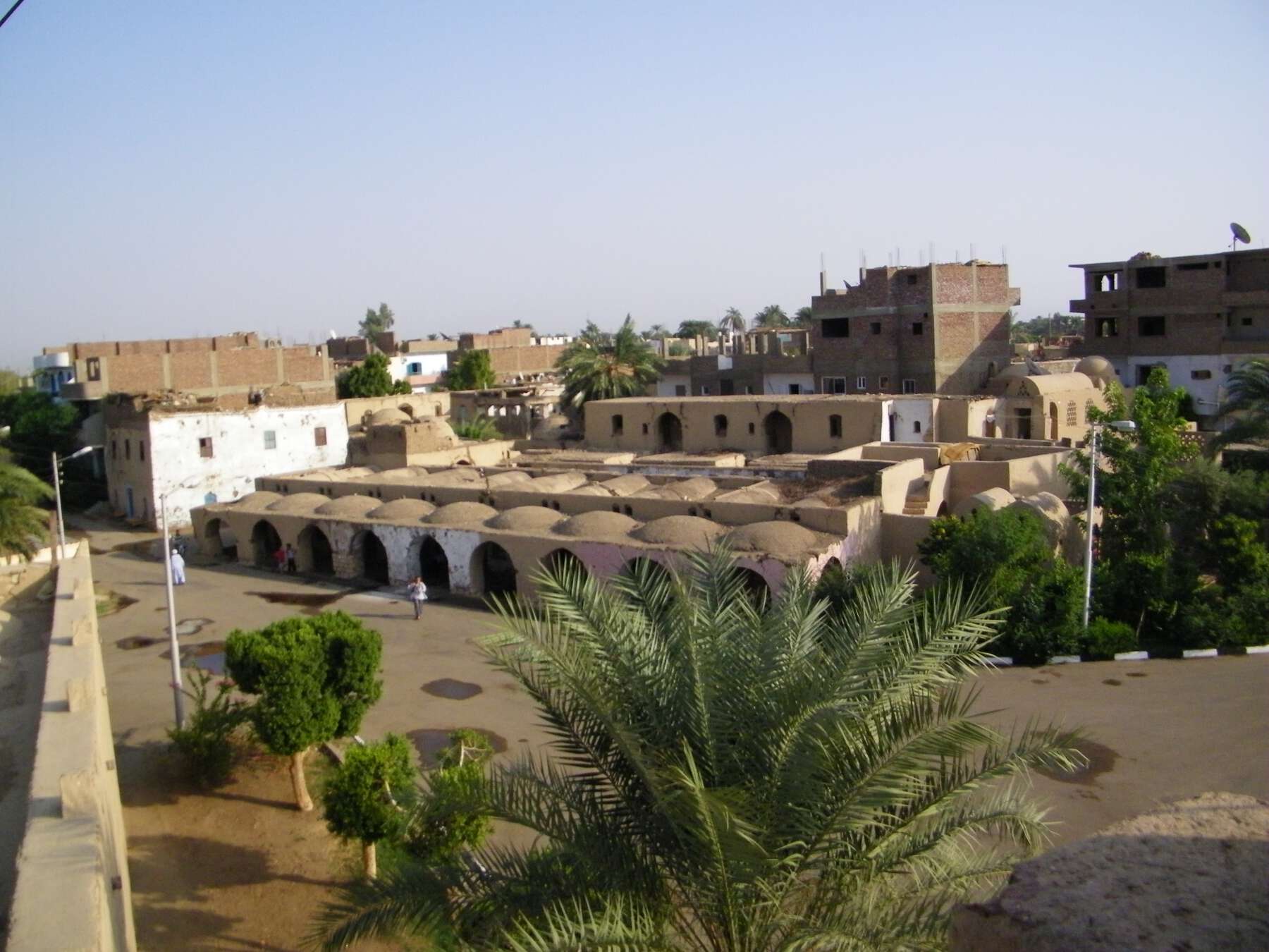 Figure 3.1
In 2010, in collaboration with UNESCO and the Luxor Governorate, the World Monuments Fund (WMF) undertook a cultural mapping exercise within the community to understand how residents value and interact with the fabric and space of the village, as well as the social, economic, and environmental factors influencing those values and interactions (; ). The mapping also sought to amplify the underrepresented voices of the local community in decision making about their home and their future. In this sense, the mapping was both essential and instrumental in its aims; it attempted to confirm or challenge assumptions made by experts in the heritage planning process and to explore the societal values that were underpinning physical adaptation.
The cultural mapping was not asset driven; it did not ask residents to identify what they valued within the village. Issues of scale influenced the approach, as the aim was to understand changes to fabric and people-space dynamics more intimately, at the scale of individual buildings and even rooms, not just at the village level. It also included spaces and structures that were not original to the Fathy design or even considered “heritage” because of their very recent construction. In this way, the exercise sought to understand the drivers of spatial change and the societal values underpinning them, rather than simply understanding the values ascribed to what was a priori considered “heritage.”
The process engaged observational and discursive methods of (spatial) ethnography. The data collection was consultative (two-way) and consisted primarily of interviews and focus groups with local residents over a two-week span (fig. 3.2a and fig 3.2b). This augmented and informed GIS mapping and photo documentation used to locate and characterize architectural interventions, along with mapping to spatialize familial relationships in the village. The process was also co-creative, in that the team collaborated with residents to produce a community film, providing a less filtered conduit for local voices ().
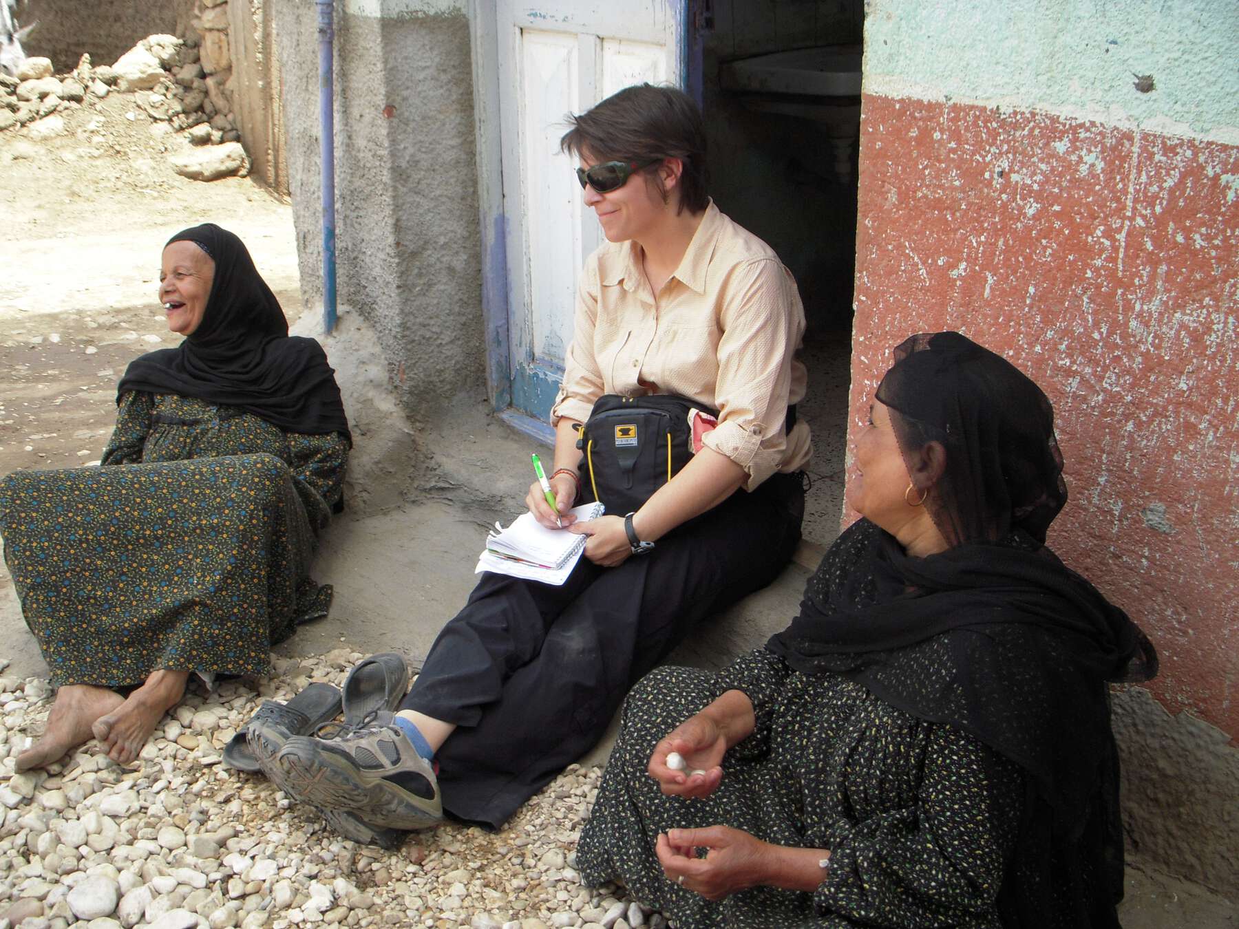 Figure 3.2a
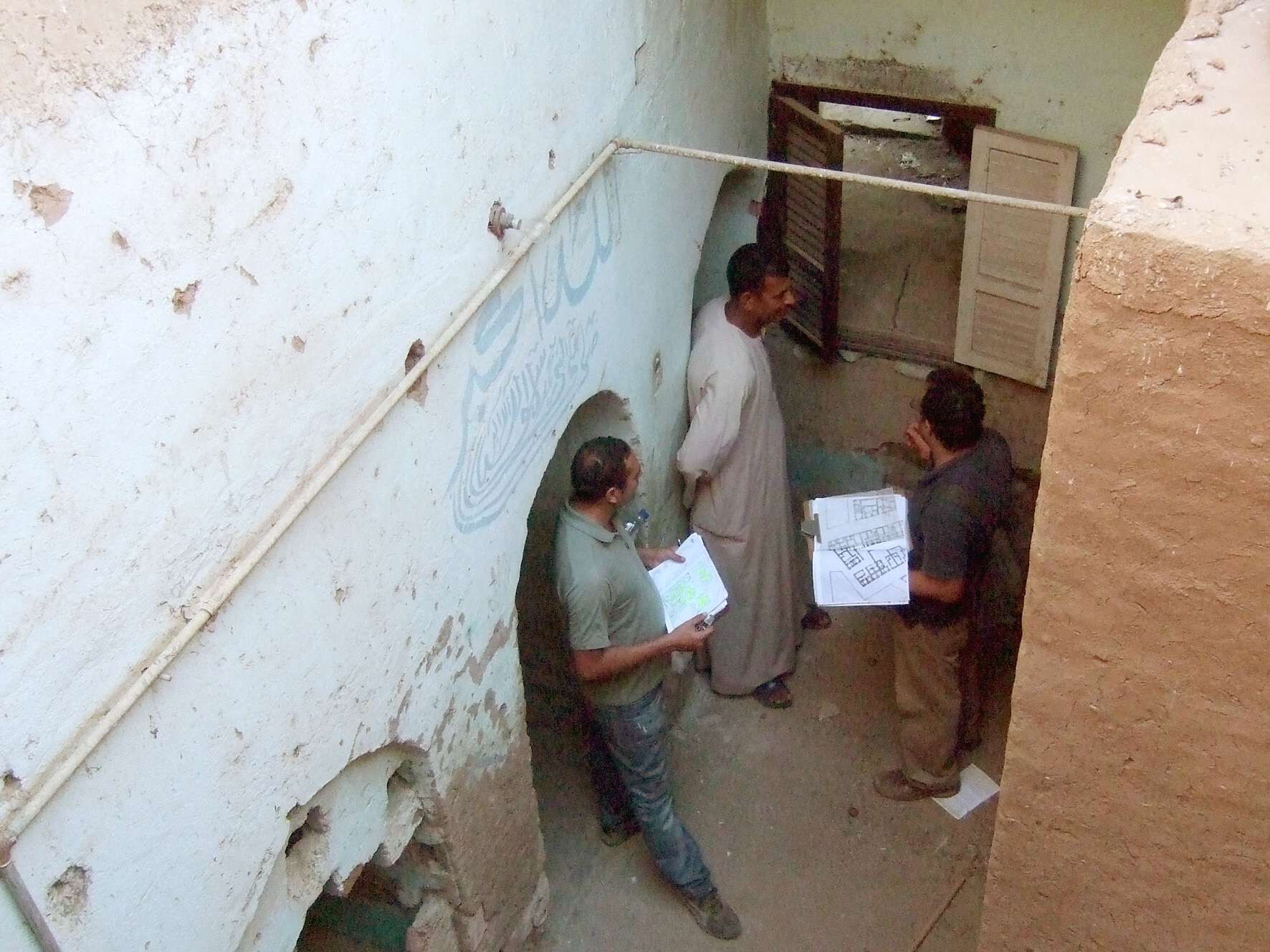
Cultural mapping confirmed and explained a number of heritage-versus-societal-value tensions by seeking to spatialize those values—that is, to understand them in relation to the design and materiality of the village. First, there is a profound respect within the community for the legacy of Hassan Fathy. This countered assumptions by heritage professionals, who believed that the loss of original fabric indicated a lack of awareness and appreciation on the part of the residents. New material choices not in keeping with Fathy’s original earthen construction are largely a result of groundwater conditions that are particularly deleterious to the traditional earthen construction (fig. 3.3).
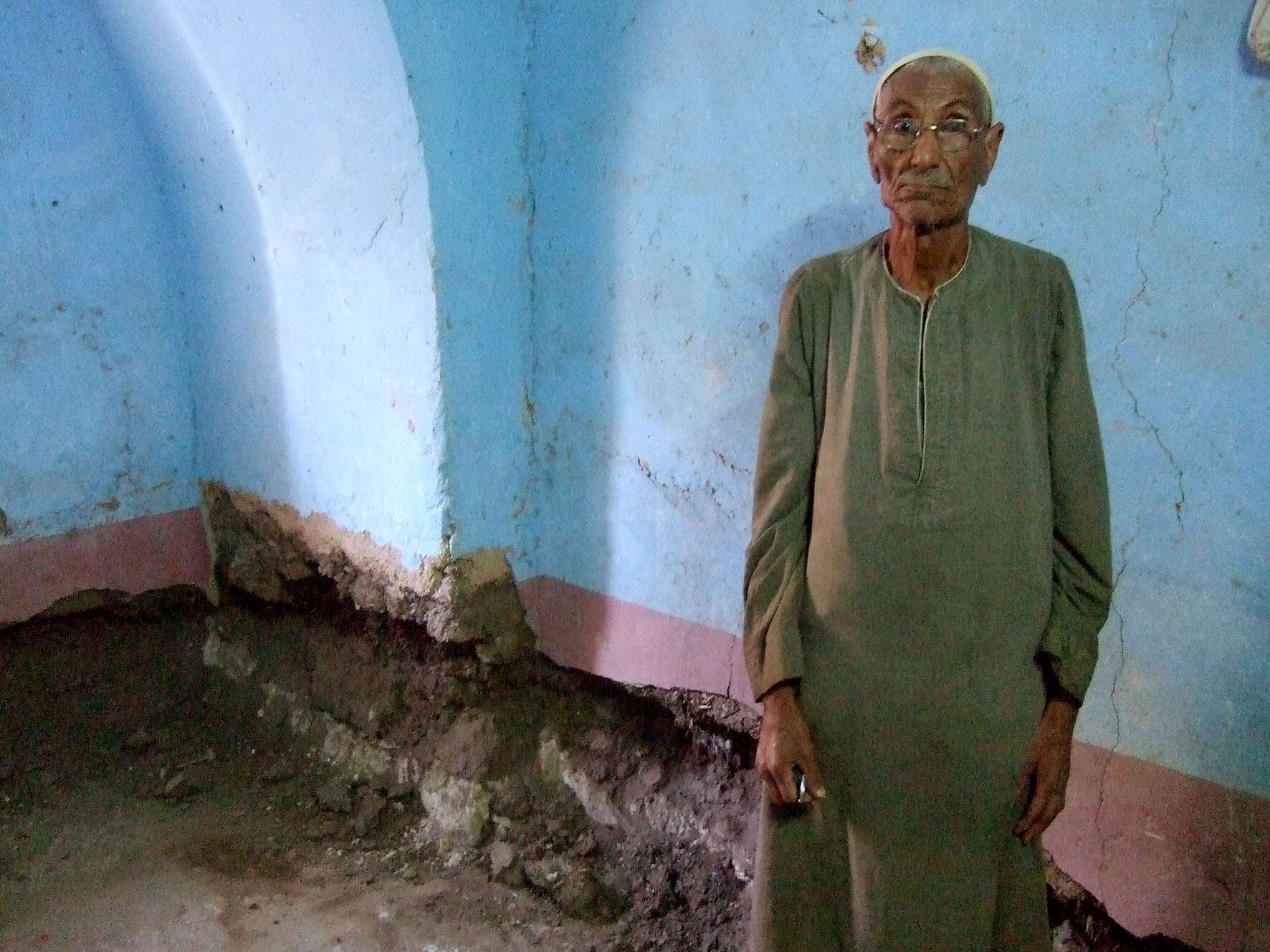 Figure 3.3
Population growth also contributes to tensions between heritage and societal values. The village as constructed was designed to house 77 families; it now accommodates 174 families. The relatively large average size and the increasing number of households within New Gourna can be attributed to three main factors. First, married sons are expected to raise their families close to or in their parents’ home, sharing commodities and tasks and supporting aging parents. As it is not possible to expand the footprint of buildings or acquire adjacent land, many married sons live in the same dwelling as their parents, often on floors above. Second, some men take two or more wives, and custom requires them to provide housing for all wives equally. In several cases, original Fathy homes are divided to accommodate two households. Third, daughters remain in their parents’ home until marriage. The costs associated with marriage in Egypt have climbed dramatically in recent decades, and young people are consequently staying home longer and marrying older. These familial conditions help to explain the demolition of many of Fathy’s domed houses (fig. 3.4), which preclude the addition of stories and compel families to build anew. Protecting these societal values of familial cohesion and interdependence challenged heritage-value-driven proposals to de-densify the village and demolish some of the more egregious new structures that diminish its architectural significance (fig. 3.5).
Finally, the community strongly values the intimate public spaces within the village: alleys, khan, communal baking ovens, and shared agricultural fields (fig. 3.6), (fig. 3.7).6 The fields especially are an important source of food and income for many families. Close proximity enables children to walk to and from school independently, which parents value and which may be a factor in village literacy rates that are higher than the national average (fig. 3.8). These findings called into question initial proposals by UNESCO to relocate the school and undertake new construction on portions of the fields as part of its preliminary heritage-based master plan ().
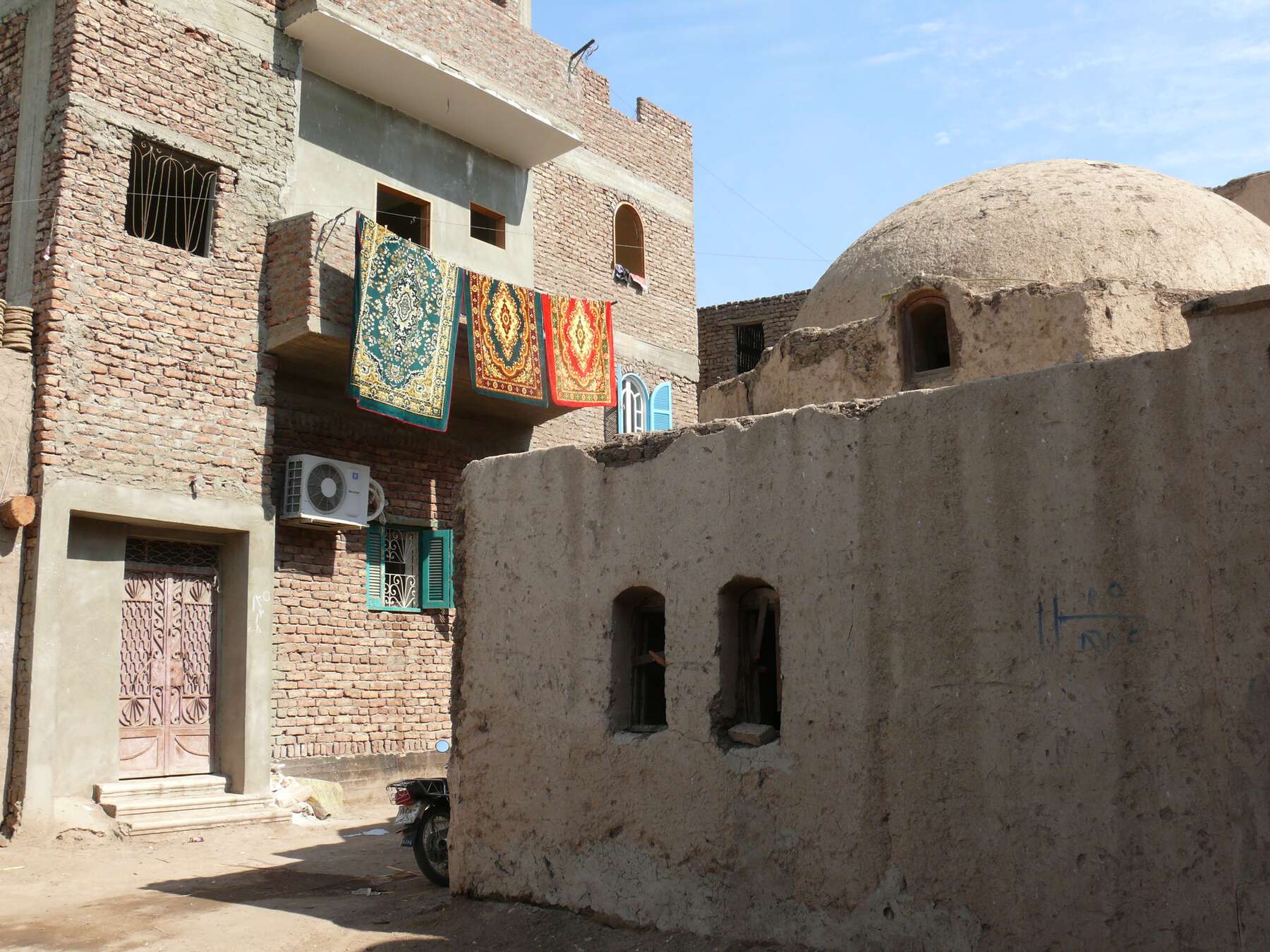 Figure 3.4
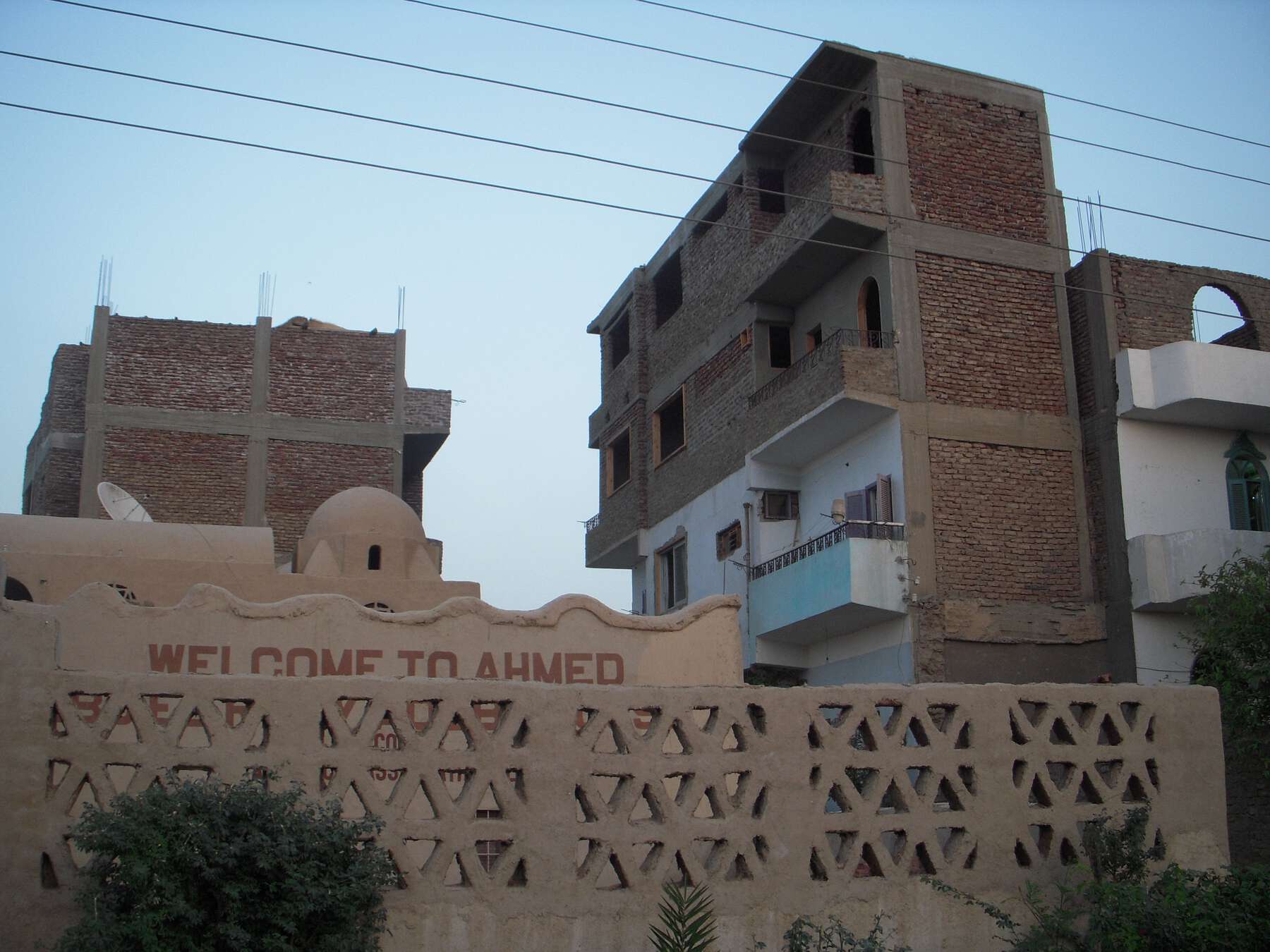 Figure 3.5
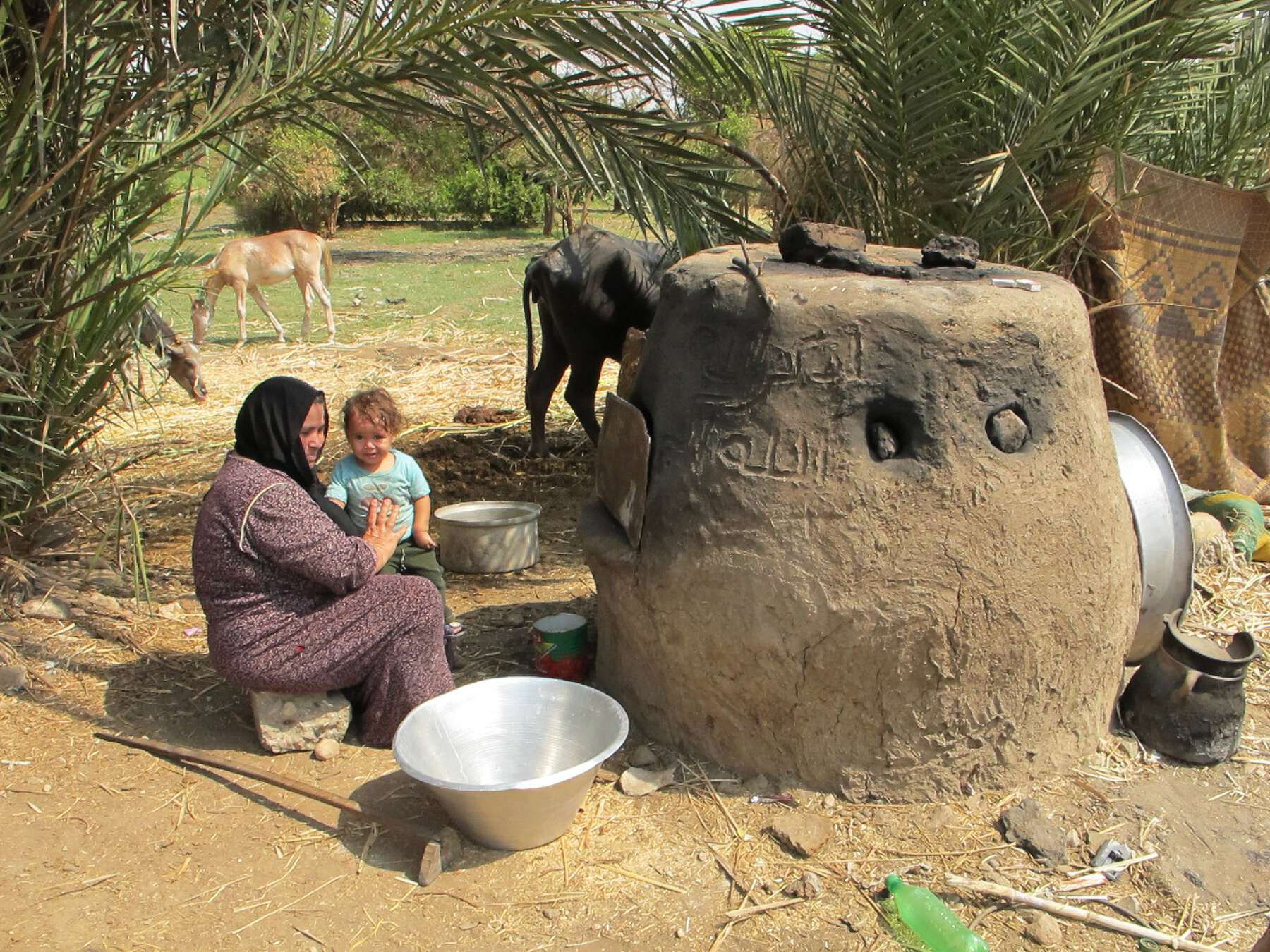 Figure 3.6
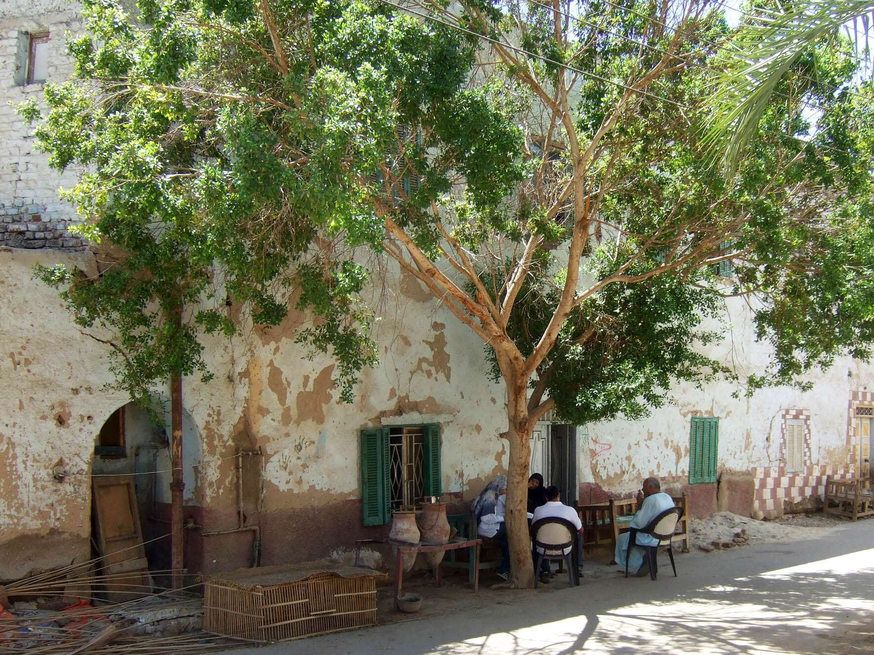 Figure 3.7
 Figure 3.8
Reconciling these tensions between heritage and societal values compels a reckoning of the significant social-spatial relationships born of Fathy’s design, which extend beyond its surviving tangible assets. As Fairclough notes, “Heritage … is more than just an issue of preservation, it is an issue of use, and of value in the wider meaning, of benefits—we should worry more about function not form or fabric, be more accepting of change, more content to keep the often intangible fundamentals of the past’s material remains rather than its sometimes more superficial fabric” (, 247). Cultural mapping, by augmenting traditional forms of heritage documentation and assessment through a “dialogical encounter” (), can provide insight into these social-spatial relationships so as to inform more effective and relevant heritage management.
Conclusions
Returning to the early example of the Mission Héliographique, we are reminded of the polemic power and complexity of heritage and its mapping: “The Mission’s archives were a muffled voice of dissent … demonstrating how idiosyncratic, complicated, and contested history can be” (, 317). The potential of cultural mapping lies in its capacity to both investigate and celebrate this power and complexity.
Mapping fundamentally valorizes some places, practices, and relationships, and in so doing devalues others. The heritage enterprise thus invites a philosophical burden of proof. While in earlier eras, heritage values alone could rationalize conservation as an essential obligation to future generations, contemporary conditions compel more instrumental associations to societal values. Cultural mapping can effectively mediate between the two approaches by spatializing their value relationships, using a range of disciplinary perspectives and tools. Christopher R. Gibson notes,
Research aimed at engaging communities and contributing progressively to improved social relations has a lot to gain from crossing disciplinary boundaries—but … researchers should do so from a position of methodological strength developed from within a disciplinary framework…. Cultural mapping is more a platform for integrating various kinds of inquiry—a horizontal “board” onto which all kinds of quantitative and qualitative data can be pegged to suit the particular questions being asked. (, 78)
Clearly defining methodological aims and points of intersection is paramount in the effective implementation of cultural mapping for heritage management. Whether a community-based form of empowerment and knowledge transfer or an assessment by government to inform public policy, cultural mapping’s multimodal and transdisciplinary nature, along with its activist potential, can serve a variety of ends, and in so doing encourage communities to keep creating and re-creating heritage through regenerative processes.
Notes
- “Heritage places” can be historic buildings, structures, or settlements; monuments or memorials; archaeological sites; cultural landscapes; or other spatial forms that have been valorized as heritage. ↩
- See Avrami and Mason, earlier in this volume, for more on this. ↩
- See Avrami and Mason, earlier in this volume, for a more detailed discussion of societal values in relation to heritage. ↩
- As examples of community guides and handbooks for asset mapping, see those developed by Fuller, Guy, and Pletsch (); Community Partnership for Arts and Culture (); and Municipal Cultural Planning Incorporated (). ↩
- See Avrami and Mason, earlier in this volume, for more on this. ↩
- Fathy drew upon the traditional concept of a khan as a trading center and designed the structure with workshops for craftspeople and a vaulted, semi-enclosed gallery for public display of goods. The latter continues to serve as a sheltered community gathering space near the mosque. ↩
References
- Avrami, Erica, Gina Haney, Jeff Allen, and William Raynolds. 2011. New Gourna Village: Conservation and Community. New York: World Monuments Fund. https://www.wmf.org/sites/default/files/article/pdfs/New%20Gourna%20Report%20Final%2015%20Meg.pdf.
- Brown, Deidre, and George Nicholas. 2012. “Protecting Indigenous Cultural Property in the Age of Digital Democracy: Institutional and Communal Responses to Canadian First Nations and Māori Heritage Concerns.” Journal of Material Culture 17 (3): 307–24.
- Community Partnership for Arts and Culture. 2009. “Guide to Mapping Neighborhood Arts and Cultural Assets.” http://www.cultureforward.org/Reference-Desk/Research-Library/neighborhoods/Guide-to-Mapping-Neighborhood-Arts-and-Cultural-Assets.
- Concilio, Grazia, and Ilaria Vitellio. 2016. “Co-creating Intangible Cultural Heritage by Crowdmapping: The Case of Mappi[na].” In 2016 IEEE 2nd International Forum on Research and Technologies for Society and Industry Leveraging a Better Tomorrow (RTSI), September 7–9, 2016. https://ieeexplore.ieee.org/document/7740553.
- Daniel, Malcolm. 2004. “Mission Héliographique, 1851.” In Heilbrunn Timeline of Art History. New York: Metropolitan Museum of Art. http://www.metmuseum.org/toah/hd/heli/hd_heli.htm.
- Di Pasquale, Davide, Antonella Lerario, Nicola Maiellaro, and Paolo L. Scala. 2013. “Open Source Interactive Map of Albania Cultural Heritage.” IERI Procedia 4:38–90. https://www.sciencedirect.com/science/article/pii/S2212667813000580.
- Duxbury, Nancy, W. F. Garrett-Petts, and David MacLennan, eds. 2015. Cultural Mapping as Cultural Inquiry. Routledge Advances in Research Methods 13. New York: Routledge.
- Evans, Graeme, and Jo Foord. 2008. “Cultural Mapping and Sustainable Communities: Planning for the Arts Revisited.” Cultural Trends 17 (2): 65–96.
- Fairclough, Graham. 2014. “What Was Wrong with Dufton? Reflections on Counter-Mapping: Self, Alterity and Community.” In Who Needs Experts? Counter-Mapping Cultural Heritage, edited by John Schofield, 241–48. Heritage, Culture and Identity. Farnham, UK: Ashgate.
- Fisch, Stefan. 2008. “National Approaches to the Administration of Historical Heritage.” In National Approaches to the Governance of Historical Heritage over Time: A Comparative Report. Edited by Stefan Fisch. Amsterdam: IOS.
- Freitas, Raquel. 2016. “Cultural Mapping as a Development Tool.” City, Culture and Society 7 (1): 9–16.
- Fuller, Tony, Denyse Guy, and Carolyn Pletsch. 2001. Asset Mapping: A Handbook. Guelph, Canada: University of Guelph. https://community-wealth.org/content/asset-mapping-handbook.
- Gibson, Christopher R. 2010. “Place Making: Mapping Culture, Creating Places: Collisions of Science and Art.” Local-Global: Identity, Security, Community 7:66–83.
- Gregory, Derek. 1978. Ideology, Science and Human Geography. London: Hutchinson.
- Guilfoyle, David R., and Myles B. Mitchell. 2015. “Compliance-Based Archaeological Heritage Management and Place-Based Participatory Mapping for Negotiated Outcomes.” Australian Archaeology 80 (1): 80–90.
- Hadzic, Leila, Adisa Dzino-Suta, Rand Eppich, Aida Vezic, and José Luis Izkara-Martinez. 2015. “Participatory Imaging Mapping of Cultural Heritage across Internal Borders: Stolac, Bosnia And Herzegovina.” International Archives of the Photogrammetry, Remote Sensing and Spatial Information Sciences 40 (5): 195–200.
- Harley, John Brian. 1989. “Deconstructing the Map.” Cartographica 26 (2): 1–20.
- Harvey, David. 1989. The Condition of Postmodernity: An Enquiry into the Origins of Cultural Change. Cambridge, MA: Blackwell.
- Harvey, David. 2001. Spaces of Capital: Towards a Critical Geography. New York: Routledge.
- Hayden, Dolores. 1995. The Power of Place: Urban Landscapes as Public History. Cambridge, MA: MIT Press.
- ICOMOS. 1931. The Athens Charter for the Restoration of Historic Monuments–1931. [Paris]: ICOMOS. http://www.icomos.org/en/charters-and-texts/179-articles-en-francais/ressources/charters-and-standards/167-the-athens-charter-for-the-restoration-of-historic-monuments.
- Kang, Kristy H. A. 2016. “Mapping the Intangible Cultural Heritage of Ethnic Communities: Designing an Interactive Cultural History of Koreatown.” Paper presented at 2016 22nd International Conference on Virtual Systems and Multimedia (VSMM), October 17–21, 2016. https://ieeexplore.ieee.org/document/7863211.
- Kim, Annette Miae. 2015. Sidewalk City: Remapping Public Space in Ho Chi Minh City. Chicago: University of Chicago Press, 2015.
- Kosek, Jake. 1998. “Unintended Consequences: Three Views of Mapping: Jake Kosek.” Whole Earth 94:55.
- Kretzmann, John P., and John L. McKnight. 1993. Building Communities from the Inside Out: A Path toward Finding and Mobilizing a Community’s Assets. Evanston, IL: Center for Urban Affairs and Policy Research, Northwestern University, 1993.
- Kunzmann, Klaus. 2004. “Culture, Creativity and Spatial Planning.” Town Planning Review 75 (4): 383–404.
- Lefebvre, Henri. 1974. Le production de l’espace. Paris: Éditions Anthropos.
- Liew, Kai Khiun, and Natalie Pang. 2015. “Neoliberal Visions, Post-Capitalist Memories: Heritage Politics and the Counter-Mapping of Singapore’s Cityscape.” Ethnography 16 (3): 331–51.
- Longley, Alys, and Nancy Duxbury. 2016. “Introduction: Mapping Cultural Intangibles.” City, Culture and Society 7 (1): 1–7.
- Monteiro, Stephen. 2010. “Nothing Is So Dangerous as Hypothesis: The Mission Héliographique, Photography, and the Spectacle of History.” Photography and Culture 3 (3): 297–320.
- Municipal Cultural Planning Incorporated. 2010. Cultural Resource Mapping: A Guide for Municipalities. Ontario, Canada: Municipal Cultural Planning Incorporated.
- Ortega Nuere, Cristina, and Fernando Bayón. 2015. “Cultural Mapping and Urban Regeneration: Analyzing Emergent Narratives about Bilbao.” Culture and Local Governance / Culture et gouvernance locale 5 (1/2): 9–21.
- Pillai, Janet. 2013. Cultural Mapping: A Guide to Understanding Place, Community and Continuity. Petaling Jaya, Malaysia: Strategic Information and Research Development Centre.
- Pini, Daniele. 2011. Safeguarding Project of Hassan Fathy’s New Gourna Village: A UNESCO Initiative—Master Plan Final Report. Paris: UNESCO.
- Poole, Peter. 2003. Cultural Mapping and Indigenous Peoples: A Report for UNESCO. Accessed January 30, 2017. https://www.creativecity.ca/database/files/library/unesco_cultural_mapping.pdf.
- Redaelli, Eleonora. 2012. “Cultural Planning in the United States: Toward Authentic Participation Using GIS.” Urban Affairs Review 48 (5): 642–69.
- Schuster, J. Mark. 2002. “Making a List and Checking It Twice: The List as a Tool of Historic Preservation.” Paper prepared for the Biannual Conference of the Association for Cultural Economics International, Rotterdam, the Netherlands, June 13–15, 2002. Accessed January 17, 2017. https://courseworks2.columbia.edu/files/588327/download?download_frd=1/.
- Smith, Neil. 1990. Uneven Development: Nature, Capital, and the Production of Space. Athens: University of Georgia Press.
- Smith, Neil. 1996. The New Urban Frontier: Gentrification and the Revanchist City. London and New York: Routledge.
- Soja, Edward W. 1989. Postmodern Geographies: The Reassertion of Space in Critical Social Theory. London: Verso.
- Stone, Michael. 1998. “Map or Be Mapped.” Whole Earth Review, September 1988, 54–57.
- UNESCO [United Nations Education, Scientific, and Cultural Organization]. 2003. “Mapping of Indigenous Cultural Resources.” Accessed April 3, 2018. http://www.unesco.org/new/en/culture/themes/culture-and-development/unesco-and-indigenous-peoples-partnership-for-cultural-diversity/cultural-mapping/.
- UNESCO [United Nations Education, Scientific, and Cultural Organization]. 2009a. Building Critical Awareness of Cultural Mapping: A Workshop Facilitation Guide. Paris: UNESCO. Accessed April 3, 2018. http://unesdoc.unesco.org/images/0019/001903/190314e.pdf.
- UNESCO [United Nations Education, Scientific, and Cultural Organization]. 2009b. “Havana Communiqué on Cultural Mapping: New Perspectives on Cultural Diversity: The Role of Communities, Havana, Cuba, 7–10 February 2006.” In Building Critical Awareness of Cultural Mapping: A Workshop Facilitation Guide, 35–37. Paris: UNESCO. http://unesdoc.unesco.org/images/0019/001903/190314e.pdf.
- UNESCO [United Nations Education, Scientific, and Cultural Organization]. 2011. “Safeguarding Project of Hassan Fathy’s New Gourna Village: Preliminary Phase Document.” Accessed April 5, 2018. https://unesdoc.unesco.org/ark:/48223/pf0000192524.
- Urban Innovations Group, School of Architecture and Urban Planning, University of California, Los Angeles. 1979. The Arts in the Economic Life of the City: A Study. Harvey S. Perloff, director. New York: American Council for the Arts.
- Wickens Pearce, Margaret, and Louis R. Pualani. 2008. “Mapping Indigenous Depth of Place.” American Indian Culture and Research Journal 32 (3): 107−26.
- Wijesuriya, Gamini, Jane Thompson, and Christopher Young. 2013. Managing Cultural World Heritage. World Heritage Resource Manual. Paris: UNESCO. http://whc.unesco.org/en/managing-cultural-world-heritage/.
- Wilkins, Oliver, and World Monuments Fund. 2010. Hassan Fathy’s New Gourna: Past, Present, Future. Film. https://www.wmf.org/content/hassan-fathys-new-gourna-past-present-future.
| words